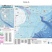
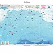
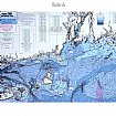
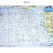
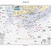
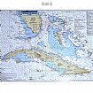
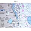
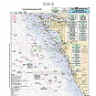
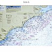
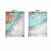
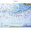
Captain Segull’s Sport Fishing Charts show you where to fish along the North American coastline from the Penobscot Bay, Maine south to Louisiana and Texas, including Bahamas and Cuba and into the Gulf of Mexico!!! Captain Segull’s Sport Fishing Charts make the most accurate fishing charts and maps on the market.
They show you fishing spots that will help you catch fish. All charts are laminated, waterproof and in full color. Average Large chart size is 19″ X 26″, small boat/kayak charts 12″ x 18″. Also highlighted are fishing holes with local names, coordinates of buoys, inlets, reefs, rigs and wrecks. Charts highlight: latitude and longitude (GPS), Loran lines, contour lines, shore services such as fuel docks, loading ramps, kayak launches, pump-out stations and restaurants.

 View Cart {{shoppingcart.totalQuantityDisplay}} Item(s)